The NASA-Unified Weather Research and Forecasting (NU-WRF) model is an observation-driven regional earth system modeling and assimilation system at satellite-resolvable scale. NU-WRF is developed upon NCAR’s Advanced Research WRF (ARW); integrates NASA’s advanced physics modules, Land Information System, satellite simulators, and ensemble data assimilation system; and can be driven by GEOS-5 and MERRA. NU-WRF is used to investigate various earth science phenomena including aerosol, cloud, precipitation, and land processes and their interactions. NU-WRF is one of three major earth system modeling systems funded by NASA’s Modeling Analysis and Prediction (MAP) program.
NU-WRF components:
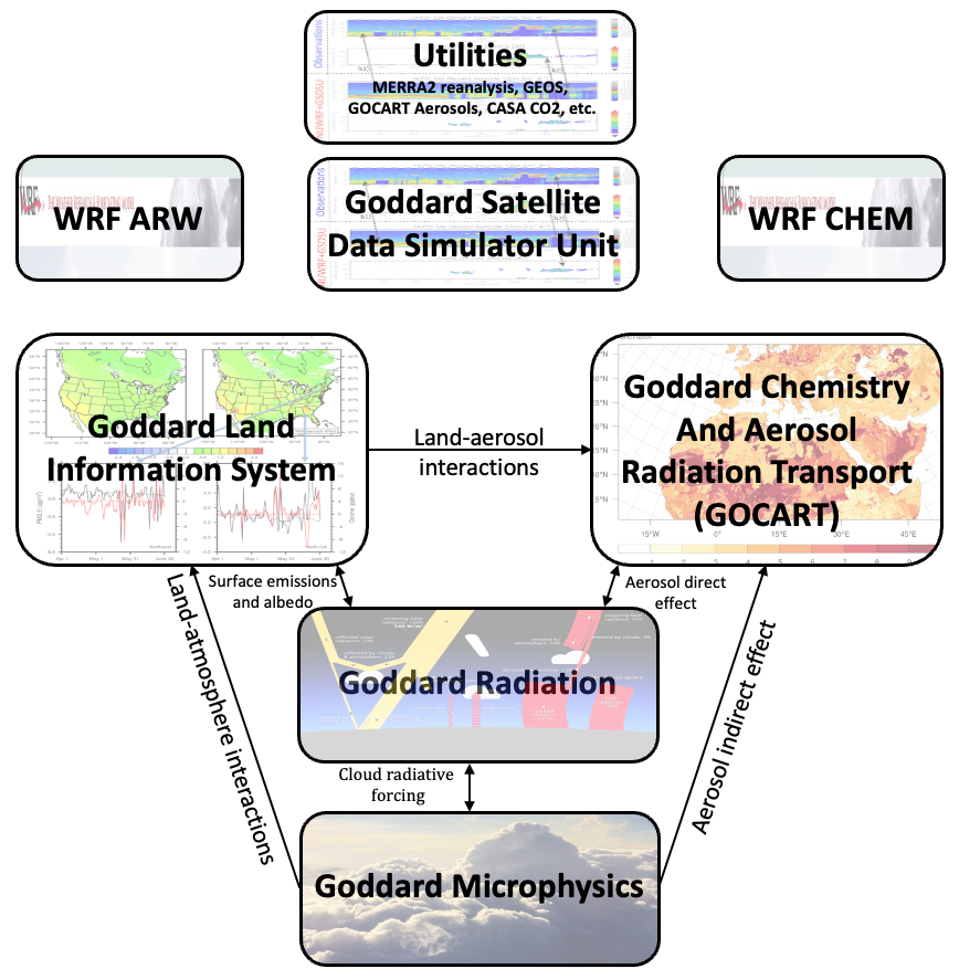
Physics modules: Goddard one-moment and two-moment bulk microphysics, Goddard shortwave/longwave radiation, Goddard Chemistry Aerosols Radiation Transport model (GOCART), and physics coupling modules.
Land Information System: GSFC Land Information System (LIS) that includes various land-surface models, physical boundary conditions (land covers, greenness, soil types, etc.), data assimilation, and model evaluations and calibration framework.
Satellite Simulator: The Goddard Satellite Data Simulator Unit (G-SDSU) predicts various satellite-observable raw-level signals (radiance or backscatter) from the NU-WRF simulations.
Lateral and initial boundary conditions: In addition to the traditional global and regional models (e.g., ERA, NCEP reanalysis), the NU-WRF can be driven by the NASA GEOS-5 global forecasting simulations or the MERRA reanalysis, and the global GOCART simulations for atmospheric aerosols.
Therefore, NU-WRF can be applied to fully coupled aerosol-cloud-precipitation-land simulations and assimilation at the satellite-resolvable scales (1~5km of horizontal grid spacing).


Scientific Objectives
NU-WRF is designed to study following areas.
- Impacts of land-surface initialization and hydrological data assimilation on mesoscale weather and regional climate.
- Feedbacks and coupling between the land surface and planetary boundary layer.
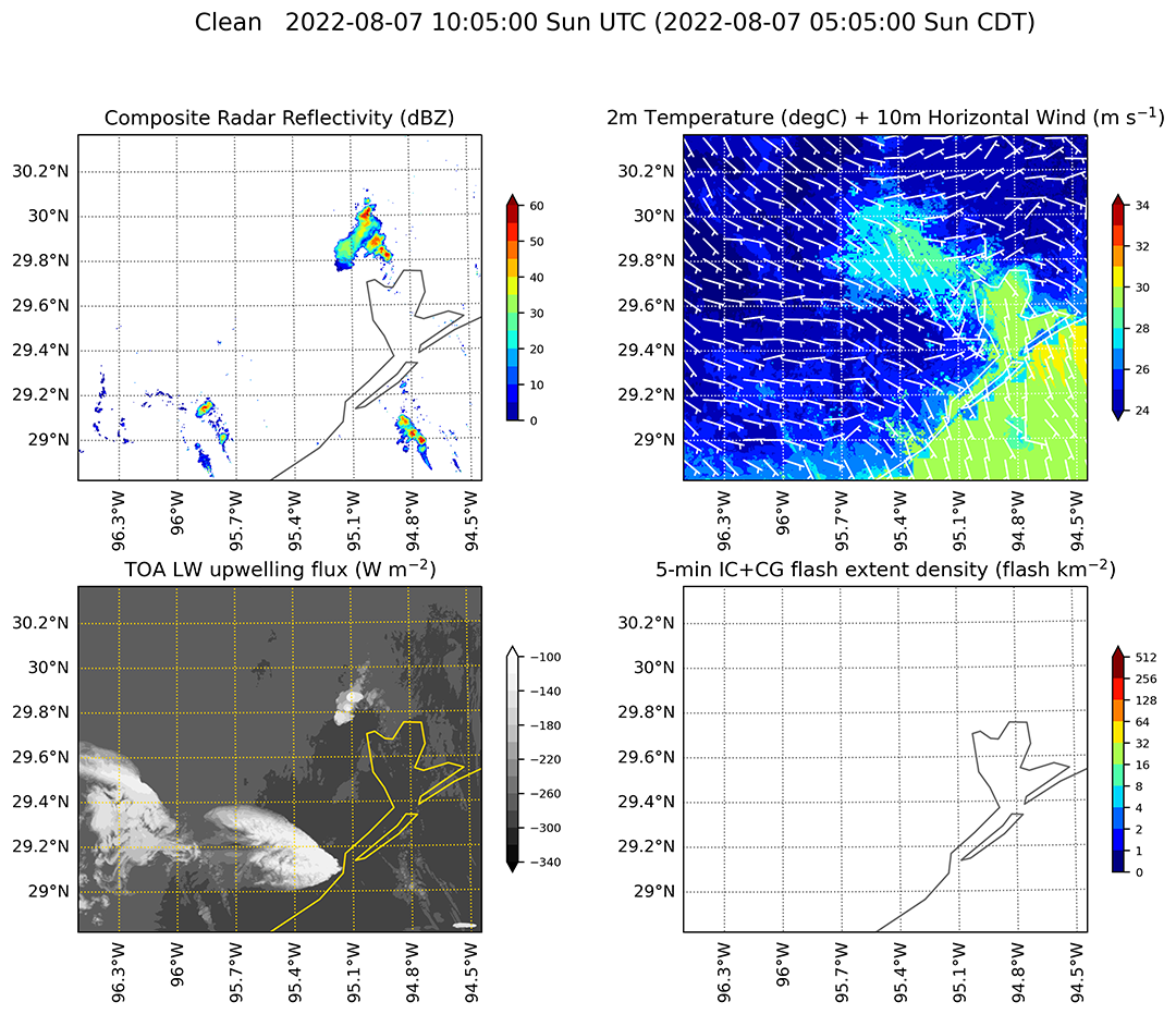
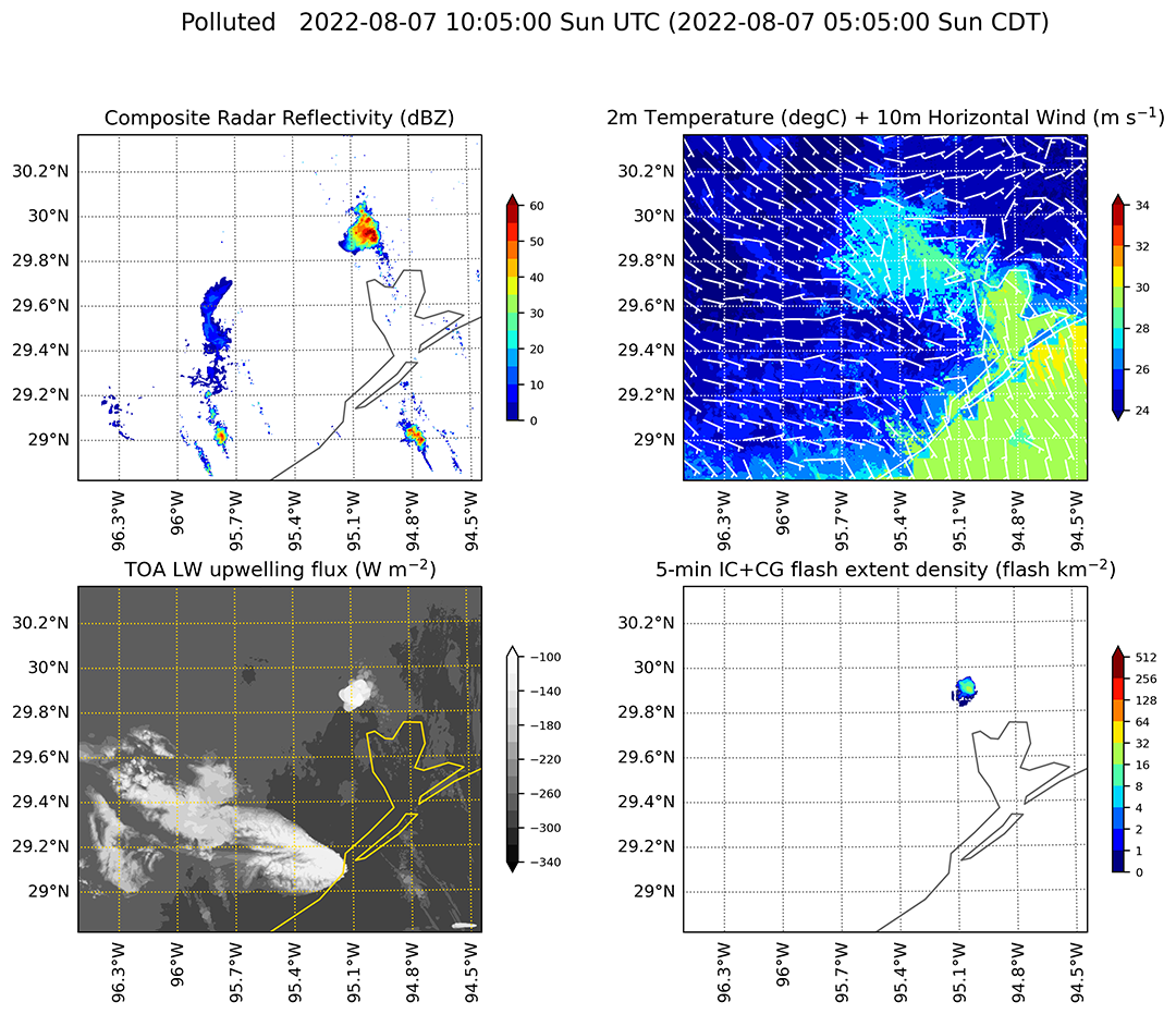
- High-impact phenomena, such as hurricane, squall line, blizzard, and drought/flood, dust storms, wildfire, heavy pollution events.
- Aerosol-cloud-precipitation interactions.
- Mesoscale processes controlling the variability of aerosols and trace gases.
- Effects of aerosols and trace gases on regional climate and air quality.
- Improve representation of regional water cycle through assimilating precipitation-affected microwave radiance from satellites.
- Semi-operational high-resolution weather forecasting to support NASA’s field campaigns.
- Downscaling NASA’s global modeling and reanalysis for regional climate.
- Supporting current and future satellite missions via satellite simulator.
- Improving CO2 flux and transport process representation via high-resolution simulation of the surface state and weather.
Project Information
Cloud, convection, and radiation: Toshi Matsui (lead), Takamichi Iguchi
Land surface and PBL: Patricia Parker, Jinwoong Yoo
Aerosol and chemistry: Zhining Tao, Dongchul Kim
Software POC: C. Cruz
Citation:
Peters-Lidard, C.D., E. M. Kemp, T. Matsui, J. A. Santanello, Jr., S. V., Kumar, J. P. Jacob, T. Clune, W.-K. Tao, M. Chin, A. Hou, J. L. Case,, D. Kim, K.-M. Kim, W. Lau, Y. Liu, J.-J. Shi, D. Starr, Q. Tan,, Z. Tao, B. F. Zaitchik, B. Zavodsky, S. Q. Zhang, M. Zupanski (2015), Integrated modeling of aerosol, cloud, precipitation and land processes at satellite-resolved scales, Environmental Modelling & Software, 67, 149–159, doi:http://dx.doi.org/10.1016/j.envsoft.2015.01.007.